The latest winter storm is expected to move through parts of the region today.
Environment Canada has issued a Winter Weather Travel Advisory for most of the region with local snowfall amounts of 5 to 10 cm possible, along with occasional blowing snow.
It says flurries and brief snow squalls may develop due to a strong and gusty northwest flow off of Georgian Bay late this morning and early this afternoon, with snow squalls expected to redevelop overnight.
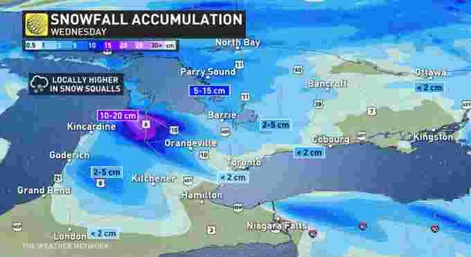
The Weather Network says a fast moving Alberta clipper system will bring widespread snow through the day with between 10-15 cm of snow possible in the hardest hit places.
Motorists should expect hazardous winter driving conditions and adjust travel plans accordingly. Travel may be hazardous due to sudden changes in the weather. Avoid travel if possible. If visibility is reduced while driving, turn on your lights and maintain a safe following distance.
For the latest forecast and weather alerts from Environment Canada, please click here.
Alerts in effect as of 9AM EST – Lake effect snow will give difficult driving conditions today southeast of Lake Superior, Lake Huron and Georgian Bay. Give yourself extra time on the roads and drive according to conditions. https://t.co/qbHBG4v9sy#ONStorm pic.twitter.com/KEVwRyQxmQ
— ECCC Weather Ontario (@ECCCWeatherON) December 22, 2021
Winter weather travel advisories are already in effect across parts of northern Ontario and cottage country for a fast moving Alberta clipper system that will bring widespread snow through Wednesday morning. #ONwx #ONstorm #ONsnow
— The Weather Network (@weathernetwork) December 21, 2021
A snow squall warning is in effect along the shores of Lake Huron as gusty winds set up a classic lake-effect snow event for parts of southern Ontario today. #ONStorm #ONsnow
— The Weather Network (@weathernetwork) December 22, 2021